Hverfjall Volcano Crater Hike in Iceland – The Ultimate Visitors Guide
Some links in this guide are affiliate links — meaning if you book or buy through them I earn a small commission at no extra cost to you (and sometimes you get a discount). Affiliate commissions never determine which places get recommended.
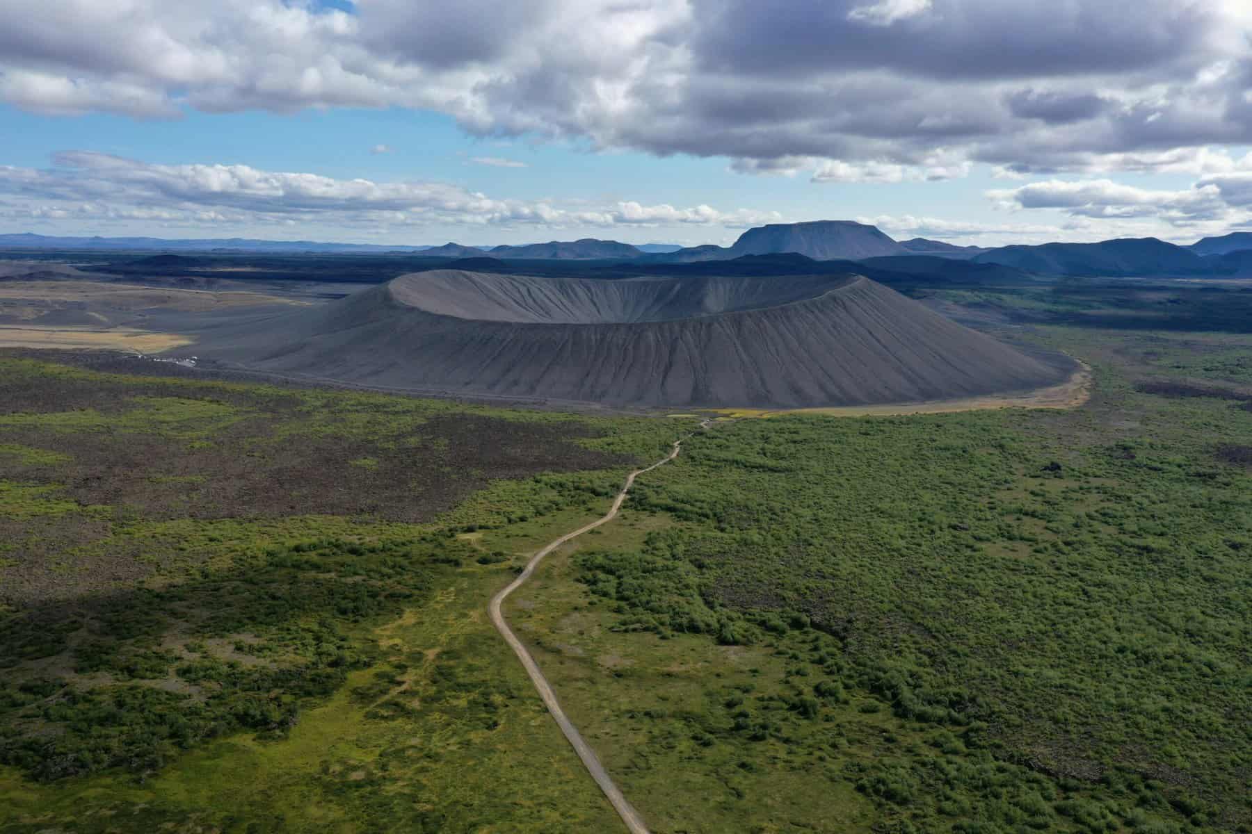
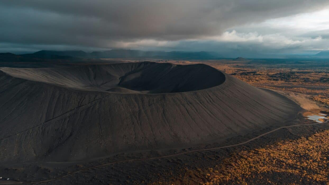
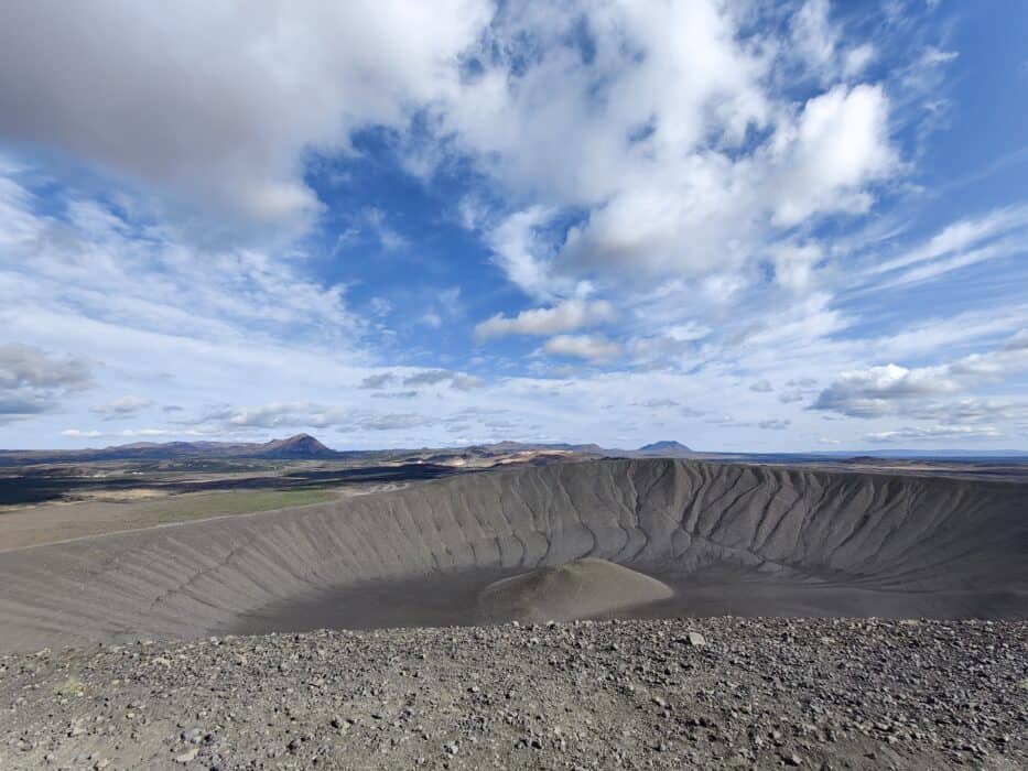
Hverfjall which is also known as ‘Hverfell’ is a large tuff ring volcano cone located in the northern part of Iceland, near Lake Mvatn. The volcano’s near perfect symmetrical cone shape makes it popular for its unique naturally occurring symmetry. The crater itself is about 1 kilometer (0.62 miles) wide and roughly 140m (459 ft) deep, making it an iconic landmark in Iceland and in my opinion, definitely worth a visit!
I recently spent 10 days in Iceland, covering the Ring road in a campervan and was fortunate enough to visit and climb the Hverfjall Volcano in decent weather. The below guide is based on my personal experience visiting and climbing Hverfjall.
Why Hverfjall Volcano in Iceland?
So why should you add the Hverfjall volcano to your Iceland itinerary? Here are some impressive facts that make Hverfjall so unique:
- Its one of the most perfectly symmetrical formed volcanoes by nature, formed in a volcanic eruption around 2,500 years ago.
- The crater itself is about 1 kilometer (0.62 miles) wide and about 140m (459 ft) deep. Hverfjall is primarily composed of loose volcanic rock and tephra, which were explosively ejected during the eruption.
- One of the biggest drawcards of climbing the Hverfjall Volcano are the panoramic views you will get of the surrounding area, including Lake Mývatn and nearby lava formations.
- All this and its easily accessible for visitors, with parking at the volcanic base, just off the Ring Road
Where is the Hverfjall Volcano located?
The Hverfjall volcano is located in northern Iceland, close to Lake Myvatn. The northern part of Iceland that is known for its volcanic landscapes and geothermal activity. Being here reminded me a lot of New Zealand where I grew up. There are a lot of volcanoes (completely dormant around the country and there is a lot of really geothermal features in different part of NZ. The nearest town to Hverfjall volcano is Reykjahlíð which is about 10 kilometers (6 miles) west of the volcano, followed by Akureyr which is about 90 kilometers (56 miles) away and is also the largest town in the north part of Iceland.
Hverfjall Volcano Hiking Map
I recomend using Alltrails for the hike up and around the crater if you prefer tracking it on a map, however the hike itself is straighforward enough given its a straight route up and around the volcanic crater.
Directions to Hverfjall Volcanic Crater
- From Reykjahlíð: The most common base for visitors to Hverfjall is Reykjahlíð. From here, the drive to the Hverfjall parking area takes about 10 minutes. Take Route 1 (Ring Road) east from Reykjahlíð and then follow signs toward Lake Mývatn. You will need to take a smaller gravel road (Road 848) to the parking area near Hverfjall.
- From Akureyri: If you’re coming from Akureyri, Iceland’s largest town in the north, the drive is about 90 kilometers (56 miles) and takes roughly 1.5 hours via Route 1.
Is the Hverfjall Volcano accessible via Public Transport?
It looks like there are no direct public transport options to Hverfjall crater. You can take Strætó bus no. 56 to Myvatn, but then still need to get a taxi to Hverfjall as there are no bustops nearby to the crater. However it is worth checking if there are prepackages Ring Road tours and even day tours which include a visit to the Hverfjall Volcano.
I recommend hiring a car if you want to visit Hverfjall and covering it as part of the Ring Road itinerary. My first visit to Iceland was very much focused on the Golden Circle and the Northern lights tour, which didn’t leave much time to travel and explore the rest of Iceland. As such, I knew the next time I visited, having a car would allow the most amount of flexibility to visit the South coast, East region and glaciers as well the Northern region where Hverfjall is located.
Where does the hike up the Hverfjall Volcano start from?
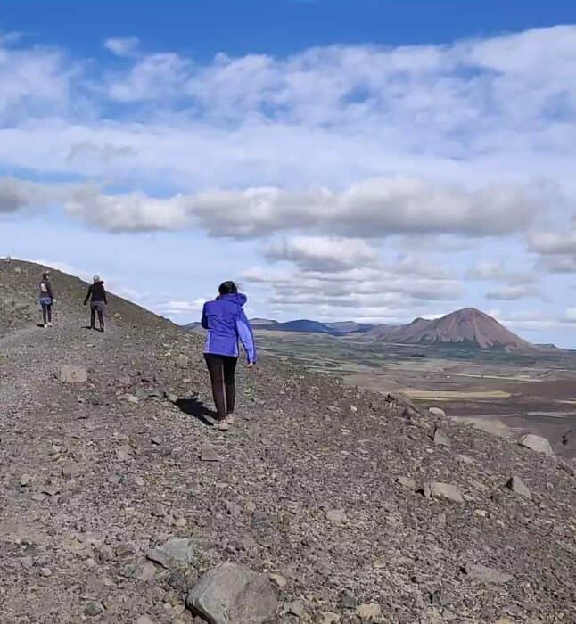
The car park for Hverfjall actually marks the starting point for the hike. There is a dedicated parking area at the base of Hverfjall, located off the gravel road.At the parking area you will find signs directing you to the Hverfjall volcano trailhead. Once you get to the trail head, follow the well-marked trail which will lead you to the summit of the crater.
How long does it take to hike the Hverfjall Volcano?
The total time to hike Hverfjall including a walk around its crater generally takes about 1.5 to 2 hours.
- To reach the crater rim from the bottom car park takes about 20 to 30 minutes to hike at a reasonable pace. However, be prepared as the trail is steep in sections, but the climb itself is not technically challenging. I didn’t see anyone with hiking poles or anything.
- Once at the crater rim, the hike around the rim of the crater, which is about 3 kilometers (1.8 miles), which typically takes 45 minutes to 1 hour depending on your pace and how often you stop for views or photos, just watch out for the wind at the top!
- The descent back down to the carpark are should take about 20 to 30 minutes.
Is the Hverfjall crater walk worth doing?
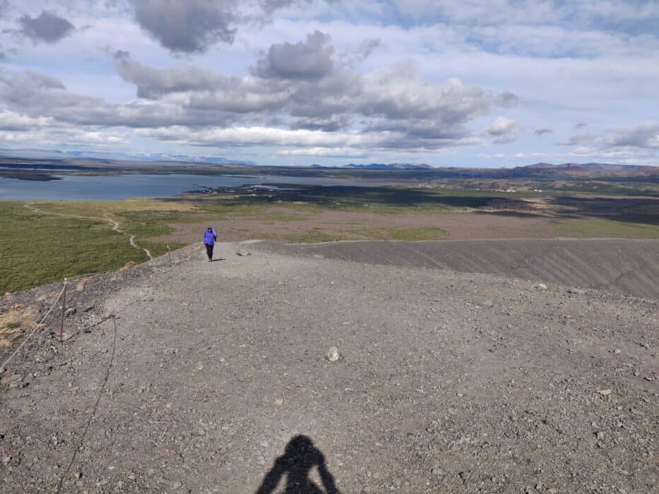
Yes, the Hverfjall Crater Walk is absolutely worth it! This stunning volcanic crater located in Northern Iceland offers some stunning panoramic views of Lake Mývatn and surrounding lava fields. Once you reach the top, you are are rewarded with views of a near-perfect tephra explosion crater, about 1 km in diameter.
The best time to visit is during summer (May–September) for clear views.
The path can be steep and rocky, so wear sturdy footwear.
Strong winds at Hverfjall
The winds around the Hverfjall crater can get extremely strong. Even if you don’t feel any wind down at the carpark level, as soon as you climb up to the crater the wind situation is completely different, with strong gusts blowing most of the time.
I would strongly recommend wearing a windproof jacket and some protective sunglasses for the wind. Lastly if you’re carrying your phone, make sure you have pockets to put your phone away in. Hverfjall will forever be remembered as the place I chipped my phone because the wind was so strong, it literally knocked the phone out of my hand landing on volcanic rocks, chipping instantly.
What is the size of Hverfjall volcano?
- Diameter: The crater is about 1 kilometer (0.62 miles) wide, making it one of the largest tephra craters in the world. For context Hverfjall’s diameter of 1 kilometer (0.62 miles) is similar to the Empire State Building laid horizontally (443 meters tall) almost fitting across the crater twice.
- Height: The rim of the crater rises approximately 140 meters (460 feet) above the surrounding landscape.
- Circumference of the Rim: The rim is roughly 3 kilometers (1.8 miles) circumference which you can walk around.
Places to see near Hverfjall Volcano
If you’re making your way around Iceland on a roadtrip, its totally worth combining the Hverfjall Volcano with nearby attractions. Below are some of the best ones that I recommend checking out
Dimmuborgir Lava Fields
- Distance from Hverfjall: About 2 kilometers (1.2 miles) away.
- Dimmuborgir is an area that is known for its unusually shaped lava formations as well as some caves. Interestingly its name actually means ‘Dark Castles’ – (which I don’t quite understand the references for), however the area is definitely worth checking out in my opinion. Its definitely instagram worthy with it labyrinth of towering lava pillars and cool rock formations.
Lake Mývatn
- Distance from Hverfjall: About 4 kilometers (2.5 miles) away.
- Lake Myvatn is probably the most well known of the surrounding attractions near to the Hverfjall Volcano. The lake famous for being a shallow lake formed by volcanic activity. The lake and surrounding landscape are famous for bird watching. For me, it was the stunning blue green shades of the lake that I was most in awe of.
Mývatn Nature Baths (Jarðböðin)
- Distance from Hverfjall: About 6 kilometers (3.7 miles) away.
- Close to Lake Myvatn are the Myvatn Nature baths, these are also referred to as the Blue Lagoon of the North. The baths are have mineral rich waters which are naturally heated from the geothermal activity and pumped into the pools via pipes. The nature baths have a surrounding view of the volcanic landscape and are a great way to unwind after a day of exploring or hiking.
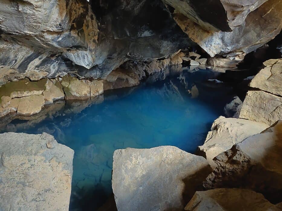
Grjótagjá Cave
- Distance from Hverfjall: About 3 kilometers (1.8 miles) away.
- A lot of people know this cave from Game of Thrones. I must admit, I did not realise this, despite having watched a few seasons. This small lava cave houses a geothermal hot spring. It was known athing is no longer encouraged due to fluctuating water temperatures, it is still a popular spot to explore, especially due to its appearance in Game of Thrones.
Hverir Geothermal Area (Námafjall)
- Distance from Hverfjall: About 8 kilometers (5 miles) away.
- Hverir is a geothermal area located near Mount Námafjall, filled with bubbling mud pots, steaming fumaroles, and vibrant sulfur deposits. The landscape is otherworldly, with the air thick with the smell of sulfur and bright orange and yellow ground formations.
So there you have it I hope the above guide has been useful in gearing you up for a road trip around Iceland. I hope you enjoy road tripping around the land of fire and ice as much as I did!
FAQs
Is the Hverfjall Volcano active?
No, Hverfjall is not currently active. It is considered a dormant volcano. Hverfjall last erupted about 2500 years ago during the volcanic activity in the region around Lake Mývatn. The volcano formed as a result of a single explosive eruption that produced the large tephra cone which still maintains its shape today.
While it is part of the Krafla volcanic system, which is active today, Hverfjall itself has shown no signs of eruption related activity since it was formed 2500 years ago. Therefore, it is not considered a threat for future eruptions.
What is the largest crater in Iceland?
The largest crater in Iceland is Askja, located in the remote central highlands within the Vatnajökull National Park. Askja is a volcanic caldera that contains the famous Öskjuvatn, the second-deepest lake in Iceland.
Are you heading to Iceland? Check out our other posts on Iceland below –